
The starting point is the small Church of San Donnino which can be reached from Pietralunga by taking the Baucca county road S.P. 106 as far as Cainardi (2 km) and then turning right towards Montemaggiore; the small church is located after approximately 5 km of winding road, at the fork to Caidominici ; here you park your car.
Opposite the Church you start walking along the footpath 112. In this section road signs need to be followed with special attention. You come across a gravel road that crosses the paved road; shortly downstream from here you take a path between two oak trees that invite you to go up. Once you complete the climb among gullies, you are back to the paved road that you run as far as the “ Madonna dei Cinque Faggi” (Our Lady of the five beech trees). Just before the small church, you are connected to a section of the “Sentiero Italia (SI)”, that you take to the left slightly downhill.
At a crossroads you find the unsafe building “Osteria delle Rote”. After the Osteria the “ Sentiero Italia” , that is well signposted, continues to climb to the top of Monte di Gragnano (770 metres).
The road continues among rocks carved by wind and water. In view of the farmhouse Prati, at the height of a hunting lodge, you leave the “ Sentiero Italia” to take the 108 trail again, that is on your left.
The route continues alongside a fence, on the right you see the “ Casella del Vescovo”, seat of a hunting company. At the fork you meet keep left, then you come close to another abandoned building (Casa Fontanelle).
You continue along a road among farm fields in the shade of downy oak trees.
After passing a bump you reach a wooded area and turn left leaving the main road, check the signs carefully. This new path, slightly hinted, winds through a grove of oak trees and invites you to walk until you come to a wide forest road leading down among evergreen conifers.
You reach the asphalted road that you run for a short distance, then you leave it to take a path that goes down to the left, highlighted by some wells on the side of the street; from here you cross a concrete platform over the stream Soara. You continue walking between the small river and the fence protecting a cultivation of truffle-growing trees. Then you see the sign of the path108 again close to an ancient ford, the path rises surrounded by an oak forest. You continue along the wood and at a fork take the right until you reach a large grassland. At a corner there are the ruins of the farmhouse Matrella.In this field keep left until you see the opposite path outlet. At the fork take the lower path, better marked by footsteps, then walk past the fences. You enter again an unpaved road that takes you close to Rapastello.
Past the farm, continuing on the paved road, in a short time you arrive at San Donnino and at the cars.
If you still have time and energy at the height of a pond you leave the main road and take a dirt track that descends among wide grasslands, extremely beautiful in spring. When you arrive at a fork, you keep the left and enter a grove until you reach a gravel road: here you leave the trail 108 and continue along the trail 112. From here you can enjoy beautiful view on the peaks of the Apennines.
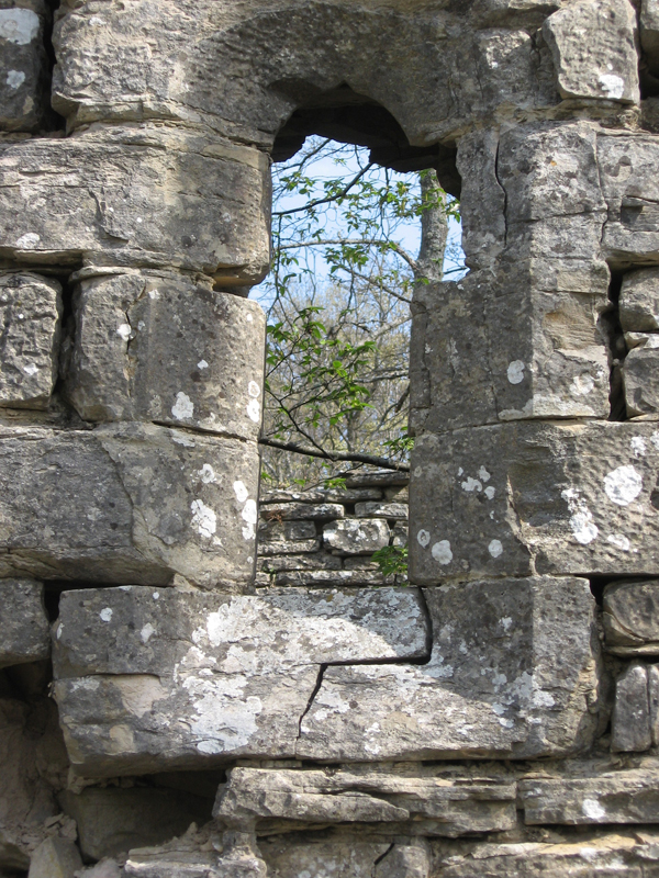
Go along the gravel path to the right and in a few minutes, after a bump, you discover the ruins of the Church of S. Angelo di Fonteroccoli, today only ruined walls adorned with two mono-hole windows.
Retrace your steps and follow the path 112 in the other direction. You get to the paved road Cainardi-Rapastello, after a short walk to the right you are back to San Donnino.
|
Period: All year round, except for winter months
|
Condition signposting: trail signposted with red/white painted signs Status maintance: Length: 13 KM Difference: 350 m Duration: 4h 30 Download PDF Download GPX Download KML Download KMZ |